Satellite Data for Predictive Mapping
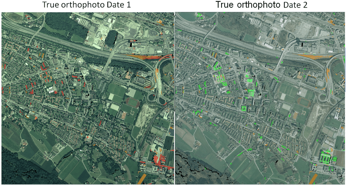
Satellite data has become a cornerstone of predictive mapping, offering unparalleled insights into Earth’s surface and atmosphere. By capturing high?resolution imagery from orbit, satellites provide continuous monitoring of environmental changes, urban growth, and natural resource distribution. This data forms the foundation for accurate spatial analysis and long?term planning.
Predictive mapping uses satellite imagery to forecast future scenarios based on current and historical trends. For example, analysts can predict deforestation rates, urban expansion, or agricultural productivity by studying satellite data over time. These forecasts help governments and organizations prepare policies that balance development with sustainability.
One of the key strengths of satellite data is its global coverage. Unlike ground?based surveys, satellites can monitor vast and remote areas that are otherwise inaccessible. This makes them invaluable for tracking climate change, monitoring glaciers, and observing ecosystems across continents.
Satellite data also supports disaster preparedness. By analyzing terrain, rainfall patterns, and vegetation cover, predictive models can identify regions at risk of floods, landslides, or droughts. Authorities can then allocate resources more effectively and implement preventive measures before disasters occur.
In agriculture, satellite?based predictive mapping helps optimize crop management. Farmers can use imagery to assess soil moisture, detect pest infestations, and monitor crop health. This information enables precision farming, reducing costs while increasing yields and minimizing environmental impact.
Another important application is urban planning. Satellite data allows city planners to anticipate population growth, infrastructure needs, and transportation demands. Predictive mapping ensures that urban development is sustainable, efficient, and aligned with future requirements.
Overall, this video emphasizes that satellite data for predictive mapping is not just about observation—it is about foresight. By combining advanced imagery with analytical models, organizations can anticipate challenges, design smarter solutions, and build resilience for the future.
Drone Mapping for Environmental Monitoring
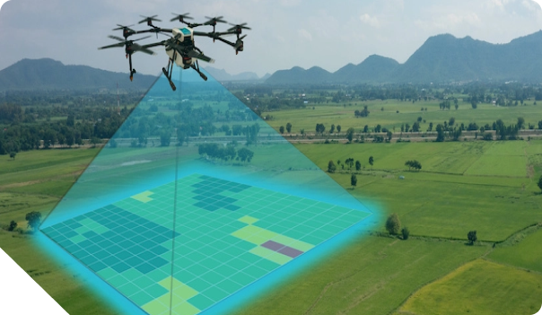
Drone mapping has emerged as a powerful tool in environmental monitoring, offering precise and efficient ways to collect geospatial data. By using drones equipped with advanced sensors and cameras, organizations can capture high?resolution imagery that provides valuable insights into land use, vegetation health, and infrastructure conditions.
One of the key advantages of drone mapping is its ability to cover large areas quickly while maintaining accuracy. Unlike traditional surveying methods, drones can access remote or hazardous locations without putting human operators at risk. This makes them particularly useful for monitoring forests, wetlands, and disaster?prone regions.
Environmental monitoring through drone mapping also supports sustainable development. By analyzing aerial imagery, companies and governments can identify patterns of deforestation, track changes in water resources, and detect pollution sources. Such information is critical for designing policies that balance economic growth with ecological preservation.
In addition, drone mapping contributes to disaster management. Real?time aerial data can help authorities assess damage after floods, landslides, or earthquakes. This enables faster response times, better allocation of resources, and more effective recovery planning.
Another important application is in agriculture, where drones can monitor crop health, soil conditions, and irrigation systems. By integrating drone data with GIS platforms, farmers can make informed decisions that improve productivity while reducing environmental impact.
Drone mapping also enhances scientific research by providing accurate elevation data, 3D terrain models, and topographic maps. These outputs are essential for studying ecosystems, predicting climate change effects, and supporting conservation projects.
Overall, this video emphasizes that drone mapping is not just a technological innovation but a strategic solution for environmental monitoring. It combines efficiency, accuracy, and sustainability, empowering organizations to protect natural resources, respond to challenges, and build a more resilient future.
Advancing Infrastructure with GIS Services
GIS Services has become one of the most important solutions for supporting modern infrastructure development. By integrating spatial data into digital systems, GIS allows companies and governments to monitor infrastructure conditions in real time and carry out detailed analysis for long?term planning.
Through digital mapping, GIS helps identify strategic locations for building roads, bridges, and public facilities. The data produced is not just static maps, but also interactive visualizations that can be accessed by different stakeholders, making decision?making faster and more effective.
One of the main strengths of GIS is its ability to combine different sources of information, such as satellite imagery, sensor data, and field reports. This integration creates a complete and accurate picture, reducing the risk of mistakes in planning.
In infrastructure management, GIS also plays a key role in monitoring asset conditions. For example, the system can detect damage to roads or bridges using sensor data, then display this information in an analytical dashboard that is easy to understand for both technical teams and management.
GIS Services also support public transparency by providing open access to information. Communities can track the progress of infrastructure projects through GIS?based portals, which helps build trust in both government and companies running the projects.
Another important benefit is sustainability. With spatial analysis, companies can plan environmentally friendly projects, avoid disaster?prone areas, and ensure that development does not harm local ecosystems. This aligns with global trends toward sustainable growth.
Overall, this video highlights that GIS Services are not just mapping tools, but strategic solutions that connect data, technology, and policy. When applied correctly, GIS improves efficiency, accuracy, and transparency in infrastructure development, while also supporting economic growth and community well?being.